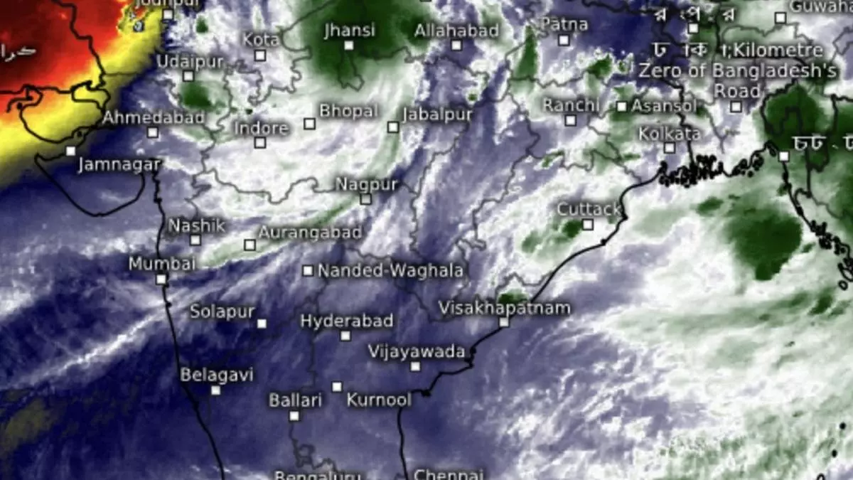
Revived depression to bring heavy rain to Central, East India through the weekend
Tuesday’s well-marked low-pressure area over north-east Madhya Pradesh re-intensified into a depression over the same region on Wednesday, and was located 60 km east-north-east of Damoh; 110 km south of Khajuraho; and 110 km south-west of Satna (all in Madhya Pradesh); and 210 km south-east of Jhansi (Uttar Pradesh). It may move slowly north-northwestwards (farther into the plains of north India) until Thursday, an India Meteorological Department (IMD) update said.
Tuesday saw the depression pour down heavy to very heavy with isolated extremely heavy falls over Madhya Pradesh while it was heavy to very heavy over Chhattisgarh, Arunachal Pradesh, Gujarat Region (North Gujarat, Gandhinagar, South Gujarat); and heavy over Himachal Pradesh, Punjab, West Uttar Pradesh, Rajasthan, Jharkhand, Assam & Meghalaya and Telangana.
Active monsoon trough
The monsoon trough remained active thanks to its bearing to the south of normal position that favours west and central India most. This alignment will likely stay for next 3-4 days. On Wednesday, yhe monsoon passed through Bikaner, Sikar, Shivpuri, the centre of depression, Pendra Road, Rourkela, Digha, and onward into the Bay waters. Another cyclonic circulation kept its vigil over south Gujarat from where an offshore trough unfolded itself southward, though cutting itself short over North Kerala.
Fresh circulation in two days
The eastern end of the trough dipping into the water throws open the possibility of fresh activity in the Bay, signs of which were available on Wednesday evening. The IMD picked up an inward-bound (from west Pacific/South China Sea) parked over central parts of Myanmar. This is expected to move into coastal Bangladesh and adjoining north-west Bay over the next two days. Numerical predictions suggest it will set up a tango with the depression over North-East Madhya Pradesh.
To merge with depression
They merge to set up a larger trough, which will bear the onslaught of dry north-westerlies from across the Pak-India border to be pushed around over east India over next few days. Numerical predictions say the combined system will be active over east India until September 20 by when the dry north-westerlies may gain larger ground over north-west India setting the stage for withdrawal of monsoon from the region. It will be close to another month before it exits the entire landscape (by mid-October)
Extreme heavy rain
Isolated extremely heavy rain is likely over West Uttar Pradesh until Friday; Uttarakhand on Thursday and Friday; and East Uttar Pradesh on Thursday. It will be isolated very heavy over Uttarakhand, West Uttar Pradesh and East Rajasthan until Friday; East Uttar Pradesh on Thursday; isolated heavy over Uttar Pradesh and East Rajasthan until Monday; Uttarakhand, Haryana-Chandigarh until Saturday; Himachal Pradesh on Thursday and Friday; and West Rajasthan on Thursday.
East and north-east India
Towards east and north-east, isolated extremely heavy rain is likely over Nagaland, Manipur, Mizoram & Tripura on Friday; isolated very heavy over Assam & Meghalaya on Friday and Saturday; Nagaland, Manipur, Mizoram, Tripura and plains of West Bengal on Friday; and Jharkhand on Saturday. It will be isolated heavy over Assam & Meghalaya for next seven days; Arunachal Pradesh, Nagaland, Manipur, Mizoram and Tripura until Monday; plains of West Bengal from Thursday to Saturday; hills of West Bengal & Sikkim on Friday; Bihar and Odisha on Friday and Saturday; and Jharkhand from Friday to Sunday.
Heavy over Madhya Pradesh
The depression will continue to bring isolated extremely heavy rain over West Madhya Pradesh on Thursday, and isolated very heavy on Friday and Saturday; and over East Madhya Pradesh on Thursday. It will be isolated heavy over Madhya Maharashtra on Friday; over entire Madhya Pradesh until Sunday; and Chhattisgarh from Sunday to Tuesday.
