Rain-driving ‘low’ weakens over Bay; models hint at successor in 10 days
The low-pressure area over the Bay of Bengal, off the South Odisha-North Andhra Pradesh coasts, weakened on Wednesday after the previous day saw heavy to very heavy rainfall over parts of Odisha and heavy rainfall over Bihar, Madhya Pradesh, Telangana, South Interior Karnataka and Kerala.
India Meteorological Department (IMD) said the parent cyclonic circulation lingered over South interior Odisha and neighbourhood, which, along with a ‘properly behaving’ monsoon trough, may sustain rain over most parts of the country except in Rajasthan, Punjab, Jammu & Kashmir and Ladakh, Haryana, Chandigarh and Delhi.
Successor likely
The rain-driving monsoon trough passed through Bikaner, Guna, Mandla, Raipur and Kalingapattanam before dipping into the West-Central Bay. So long as it remains in this position, it leaves scope for the formation of a follow-up cyclonic circulation/ ‘low’ over the Bay. Some models pick a successor circulation/ ‘low’ over the next week to 10 days with others signalling a stronger system.
This should keep the monsoon going into the third week of September variously along the West Coast, East-Central and East India and parts of Peninsular India. On an average, two depressions form in September. However, year-to-year variation in their number is quite large. Since the first one failed to make the grade, the track of the incoming circulation would bear watching.
Track of depressions
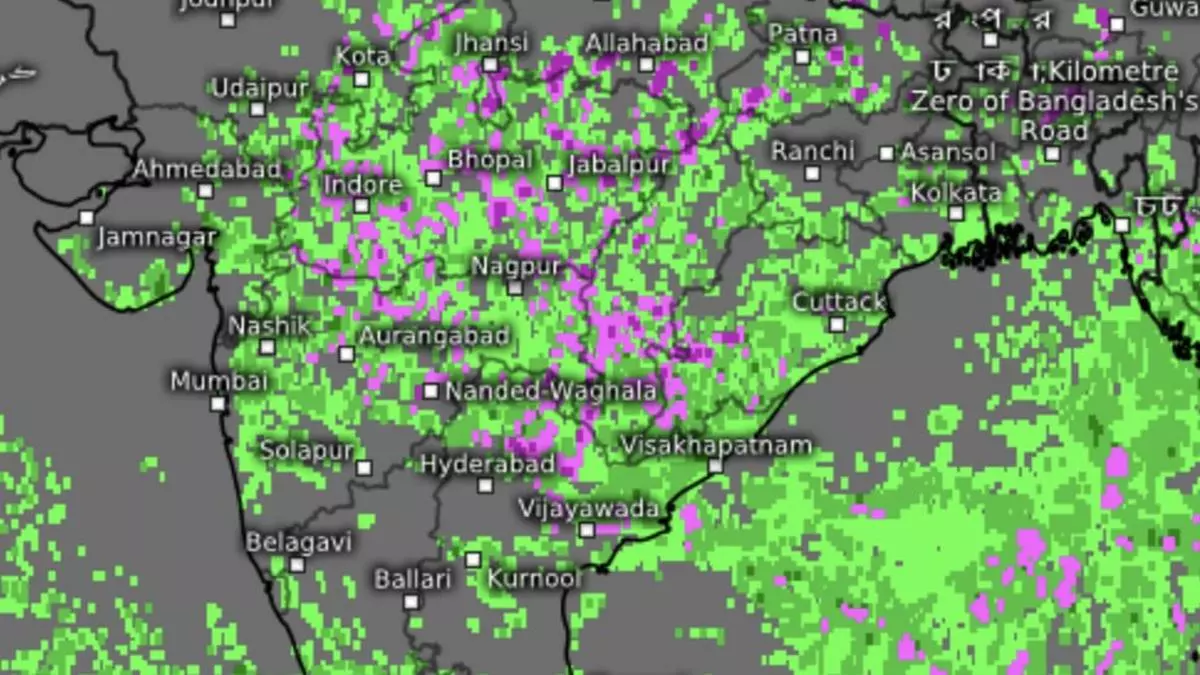
The site of genesis shifts in September southward in the Central Bay, and depressions from here have re-curved to the North (as against the normal West-North-West course to Central and West India). Occasionally, they have taken a more westerly course, reaching Gujarat, Rajasthan or even Pakistan. Satellite pictures on Wednesday afternoon showed most of the region extending from Gujarat to West Bengal variously under a rain cover (green in colour), heavy at times (pink) over isolated places.
Deficit in double-figures
IMD’s outlook Thursday and Friday said scattered to fairly widespread light to moderate rain is likely over parts of East, North-East and Central India, Uttarakhand, Uttar Pradesh, Karnataka and Telangana, along the West Coast and the Lakshadweep and Andaman & Nicobar islands. The rest of the country may witness subdued rain with isolated to scattered showers.
The surge of the monsoon has not made much of an impression on the all-India rain deficit, which remained in double-digits (11 per cent) on Wednesday. The list of deficient Met subdivisions, too, counted in at the same number with contiguous West Madhya Pradesh, Marathwada and Madhya Maharashtra joining South Interior Karnataka and Kerala in the South; East Uttar Pradesh, Bihar, Jharkhand and West Bengal in the East; and Nagaland-Manipur-Mizoram-Tripura in the North-East.
