Monsoon may peak to a new high this week as helpful features align
Monsoon is set to peak to a new high as it sails into the second half of July, normally the rainiest of the four-month season, with support from the West Pacific/South China Sea during this week, likely culminating in the formation of a strong low-pressure area over the North Bay of Bengal, as per a short-to-medium guidance from India Meteorological Department (IMD).
A combined outlook from the Climate Prediction Centre, National Centres for Environmental Prediction and the National Oceanic and Atmospheric Administration of the US tends to agree suggesting enhanced rainfall over Central, West and East India during July 17 to 23 coinciding with roaring activity in the South China Sea that lies next door to the Bay of Bengal and Indochina.
Active South China Sea
This period would likely see a monsoon ‘pulse’ originating from the South China Sea wending its way West across Indochina into the North-East Bay of Bengal where it is seen as dropping anchor and evolving as a full-fledged ‘low’ (even depression). It would gradually guide itself towards the Odisha-Andhra Pradesh coast, buffeted as it would be by strong easterly winds.
Activity would be muted over Peninsular India, especially extreme South Peninsula, before returning to normal during the week that follows (July 24 to 30) when the South China Sea may tone down pitch by a notch, with corresponding cool-off in monsoon intensity over India and most of the rainfall getting confined to Central India (Gujarat-Madhya Pradesh-Chhattisgarh-Odisha).
Helpful monsoon features
Meanwhile, on Monday morning, the IMD identified the monsoon-driving features as the main trough over land lying South of its normal position, indicating active monsoon conditions. It is likely to stay in this alignment for the next four-five days. To the West, the offshore trough ran near-full-blown from South Gujarat to north Kerala coasts. A cyclonic circulation lies over the plains of West Bengal and adjoining Jharkhand and Odisha completed the picture as it helped steer the monsoon winds from the sea.
Heavy to very heavy rain
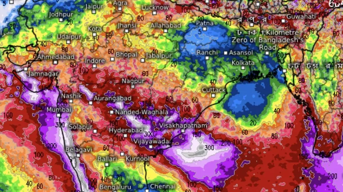
A five-day outlook said heavy to very heavy rainfall is likely over Konkan & Goa; Kerala & Mahe; Coastal and South Interior Karnataka; Madhya Maharashtra; and Gujarat. Isolated extremely heavy rainfall is likely over Konkan & Goa and the ghats of Madhya Maharashtra on Monday and Tuesday; and over Coastal Karnataka, South Interior Karnataka and Kerala & Mahe on Monday. It will be isolated very heavily over Vidarbha; Telangana; Coastal Andhra Pradesh & Yanam; North Interior Karnataka; and Marathwada.
Towards East India, the IMD sees the possibility of heavy rainfall at isolated places over Odisha on Monday, Wednesday and Thursday; over Arunachal Pradesh for three days from Monday; Assam & Meghalaya; hills of West Bengal & Sikkim; and Bihar on Monday; and over Nagaland, Manipur, Mizoram & Tripura on both Monday and Tuesday. Isolated heavy rainfall is likely over Uttarakhand and East Rajasthan for five days from Monday; and over East Uttar Pradesh on Monday and Thursday.