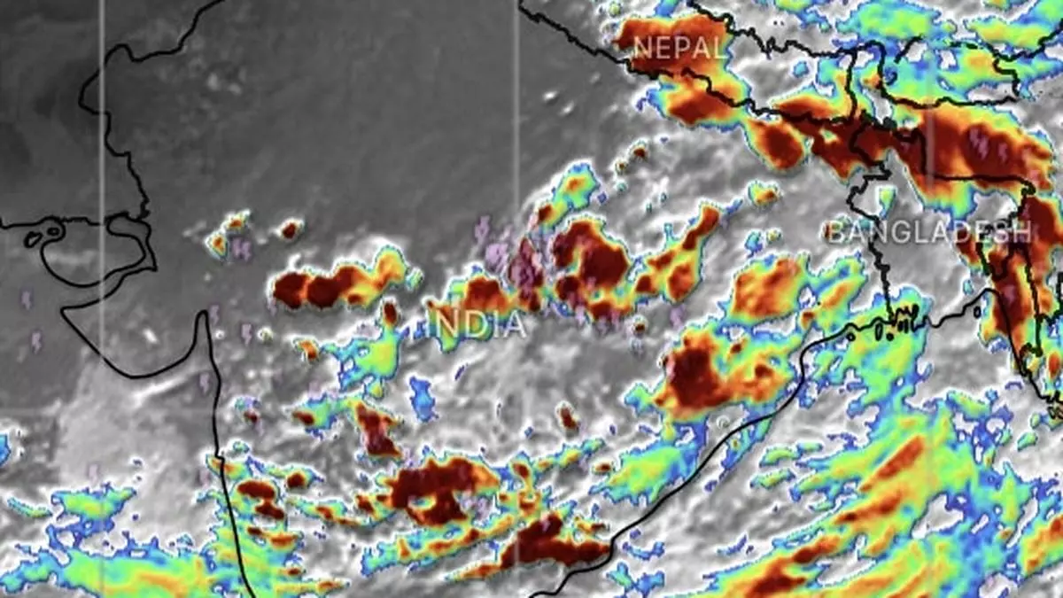
Low-pressure area forms over Bay as monsoon exits more parts in north-west India
A low-pressure area has formed earlier than expected over west-central and adjoining north-west Bay of Bengal off north Andhra Pradesh and South Odisha coasts on Tuesday afternoon after India Meteorological Department (IMD) had extended a 24-hour watch early in the morning for it to materialise.
A supportive zone of monsoon turbulence (shear) where opposing winds meet, runs roughly along Hubballi and Bellari in Karnataka and to the north of Proddatur and Nellore (Andhra Pradesh).
Withdrawal apace, but…
The ‘low’s formation was matched only by withdrawal of south-west monsoon from more parts of north-west India across Rajasthan; Gujarat; some parts of Punjab; and Haryana. The process started from Monday, at least a week behind schedule, but may get disrupted as the Bay ‘low’ crosses the Andhra Pradesh coast and drifts in towards it over Central India.
IMD’s numerical model predictions put the ‘low’ on a track to north-west towards Telangana; west Maharashtra; west Madhya Pradesh; and Gujarat over next few days, raining down all the way. Isolated heavy to very heavy rain may continue to lash Coastal Karnataka as also South Interior Karnataka on Wednesday. It will be isolated heavy over Kerala & Mahe on Wednesday, Sunday and Monday; and over Coastal Andhra Pradesh & Yanam; Telangana; and Karnataka on Wednesday.
South Peninsula outlook
Elsewhere over the South Peninsula, fairly widespread to widespread rain is predicted for next three days over Coastal Karnataka, Lakshadweep, and Kerala & Mahe; while it will be scattered to fairly widespread over Interior Karnataka, Coastal Andhra Pradesh & Yanam and Telangana, and isolated to scattered light to moderate for four subsequent days. It will be isolated to scattered light to moderate over Tamil Nadu, Puducherry & Karaikal and Rayalaseema for an entire week.
Extremely heavy rain
Isolated extremely heavy rain is forecast over West India across Konkan & Goa until Thursday; over Madhya Maharashtra on Wednesday and Thursday; and Gujarat Region (North Gujarat, Gandhinagar and South Gujarat) on Thursday. It will be isolated heavy to very heavy over Madhya Maharashtra, and Konkan & Goa until Thursday; over Saurashtra & Kutch on Thursday and Friday; and Gujarat Region until Friday.
Isolated heavy rain is likely over Madhya Maharashtra and Konkan & Goa until Friday; Marathwada on Wednesday; Saurashtra & Kutch and Gujarat Region until Saturday.
Fairly widespread to widespread light rain is likely over Konkan & Goa, Gujarat, Madhya Maharashtra and Marathwada for next three days while being scattered to fairly widespread during subsequent four days. It will be scattered to fairly widespread to moderate over Saurashtra & Kutch during the week, the IMD said.
Heavy over Central India
Isolated heavy to very heavy rain is likely over West Madhya Pradesh, Vidarbha and East Madhya Pradesh on Wednesday. It will be isolated heavy over Madhya Pradesh until Thursday; and over Vidarbha and Chhattisgarh until Thursday.
Fairly widespread to widespread rain is likely over Vidarbha and Chhattisgarh during next three days and scattered to fairly widespread during subsequent four days. It will be cattered to fairly widespread over Madhya Pradesh during for entire week.
Some gains for east
Isolated heavy to very heavy rain is likely over Assam & Meghalaya on Wednesday and Thursday as a deficit Met subdivision welcomes a fresh round of precipitation. A similar outlook is valid for Arunachal Pradesh, hills of West Bengal & Sikkim on Thursday.
Fairly widespread to widespread rain may break out over North-east India and the hills West Bengal & Sikkim during next seven days. It will be fairly widespread to widespread over the plains of West Bengal, Bihar, Jharkhand and Odisha for next three days, and scattered to fairly widespread during subsequent four days. Scattered to fairly widespread light to moderate rain is expected also over the Andaman & Nicobar Islands during the week.