IMD upgrades cyclone ‘Michaung’ outlook over Bay to severe cyclone
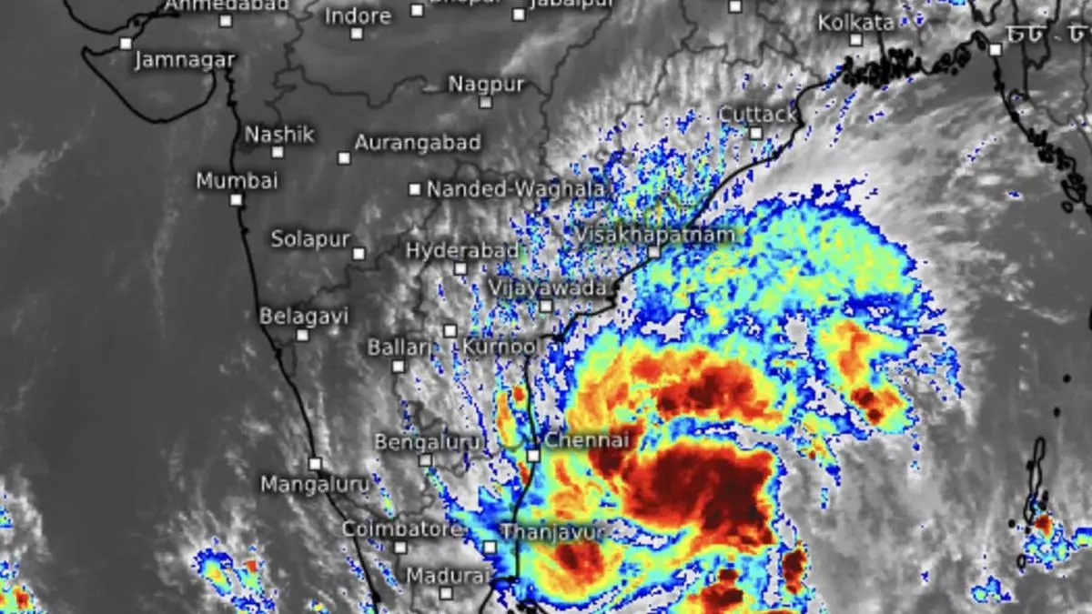
India Meteorological Department (IMD) has on Sunday forenoon upgraded the outlook for cyclone ;Michaung’ over the South-West Bay of Bengal to that of a severe cyclone with maximum sustained wind speeds of 90-100 kmph gusting to 110 kmph when as it barrels over the South Coastal Andhra Pradesh coast between Nellore and Machilipatnam on Tuesday morning.
Earlier, a prevailing depression over the South-West Bay had intensified twice over to become a deep depression and further into cyclone ‘Michaung’ (pronounced ‘Migjaum’) early in the morning, straddling the Tamil Nadu and Andhra Pradesh coast about 300 km East-South-East of Puducherry; 310 km South-East of Chennai; 440 km South-East of Nellore; 550 km South-South-East of Bapatla; and 550 km South-South-East of Machilipatnam.
Parallel to coast
The IMD had said ‘Michaung’ is likely to continue to move North-West, intensify further and reach the West-Central Bay off the South Andhra Pradesh and adjoining north Tamil Nadu coasts Monday forenoon. Thereafter, it would move nearly northwards almost parallel and close to the South Andhra Pradesh coast and cross between Nellore and Machilipatnam during forenoon of Tuesday as a cyclone with maximum sustained wind speeds of 80-90 km/hr gusting to 100 km/hr, which stands upgraded now.
Crucial MJO wave
The intensification by at least a round even as it approaches coast is thanks to the presence of a helpful Madden-Julian Oscillation (MJO) wave. The US Joint Typhoon Warning Centre is of the view the system would not have intensified beyond a depression without the handy support from the MJO wave. It periodically traverses upper levels of the atmosphere and sets up lower pressure, ascending motion of air and moisture build at the ground level. The wave has been associated with formation of low-pressure areas/cyclones and even monsoon onsets under its footprint.
Rain for TN, Puducherry
Presence of the MJO wave aside, the cyclone is seen as getting buoyed by fortuitous strong easterly bursts generated by a ridge (high-pressure area with clockwise motion of air) that sits over North-East Bay of Bengal. IMD rainfall predictions indicate light to moderate rainfall at most places over North Coastal Tamil Nadu and Puducherry with heavy to very heavy rainfall at a few places on Sunday. It would be isolated heavy to very heavy rainfall on Monday before reducing in intensity.
Andhra Pradesh, Odisha
Over South Coastal Andhra Pradesh, it would be light to moderate at most places with heavy to very heavy rain at a few places on Monday. On Tuesday, it would turn heavy to very heavy rainfall with extremely heavy falls at isolated over Coastal Andhra Pradesh and Yanam on Monday and Tuesday. Isolated heavy rain is likely over North coastal Andhra Pradesh on Wednesday. As for Rayalaseema, it would be light to moderate at most places with isolated heavy to very heavy rain on both Sunday and Monday.
Regeneration prospects
A remnant of the cyclone is seen as heading East-North-East along the coast and bring light to moderate rainfall at most places over Odisha with isolated heavy rain over South Coastal and adjoining South Interior Odisha from Monday to Wednesday with isolated very heavy rain over the same region on Tuesday. Some models are seeking to put a watch on the remnant for any signs of regeneration. But others are of the view it may not evolve to any appreciable strength since the waters are cooler over the North Bay along with the high wind shear (change in wind direction and strength with height), which can kill a developing storm.