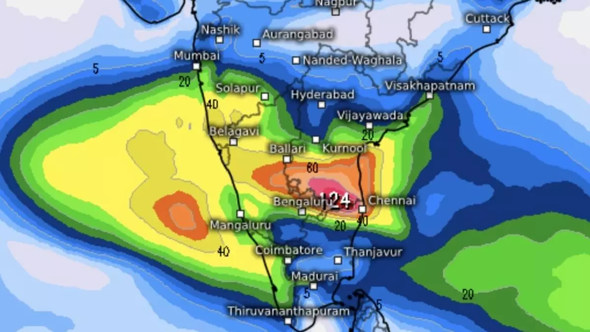
IMD Update: Depression declared over Bay of Bengal, to cross Chennai coast by Thursday morning
The first day of north-east monsoon brought extremely heavy to very heavy to heavy rain over Tamil Nadu, Puducherry and Karaikal and south interior Karnataka as a well-marked low-pressure area intensified into a depression over south-west Bay of Bengal off Tamil Nadu and Andhra Pradesh coasts, India Meteorological Department (IMD) said on Wednesday morning.
More rain forecast
Light to moderate rain is likely most places over north interior Tamil Nadu and Puducherry on Wednesday with heavy to very heavy rain at a few places and extremely heavy rain at isolated places. It would be isolated heavy to very heavy over north interior Tamil Nadu on Thursday as the depression crosses over; and light to moderate over most places over south Tamil Nadu on both Wednesday and Thursday with heavy rain at isolated places.
Simultaneously, light to moderate rain may break out over most places in south Andhra Pradesh and Rayalaseema on Wednesday with heavy to very heavy rain at a few places with extremely heavy rain at isolated places. It would be heavy at isolated places over these areas on Thursday as well. Light to moderate rain is forecast at most places over Kerala and south interior Karnataka on both Wednesday and Thursday with heavy to very heavy rainfall at isolated places.
Fishermen warning sounded
An IMD warning extended to fishermen advised not to venture into the southwest and adjoining west-central Bay on both Wednesday and Thursday. Those out at sea are advised to return to coasts in view of storm conditions set up by the depression that lay about 360 km east-south-east of Chennai; 390 km east of Puducherry; and 450 km south-east of Nellore (Andhra Pradesh) on Wednesday morning. It is likely to move in a typical west-north-west track and and cross north Tamil Nadu-south Andhra Pradesh coasts between Puducherry and Nellore, close to Chennai during early Thursday morning. This means there would not be much let-up in the rain activity being witnessed along the coast, as evidenced in the satellite pictures on Wednesday morning.
Moderate to dense clouds
Moderate to dense clouds covering parts of south Andhra Pradesh, north Tamil Nadu and adjoining interior Karnataka in the morning bore evidence to the prevailing situation. These clouds spread themselves out over an area bounded by Salem, Mysuru, Ambur, Chennai, Nellore, Ongole, Miryalaguda, Ilkal, Raichur, Hubballi, Harpanahalli, Chitradurga, Shivamogga, and Tiptur.
They appeared to rain it down varyingly heavy over Chennai, Tirupati, Tirumala, Chittoor, Madanapalle, Ambur, Bengaluru, Pavagada, Ballari, Kurnool, Proddatur, Krishnagiri, Salem, Kankanhalli, Sira, Chikkaballapur, Kolar, Dharmavaram, Koppal, Yemmiganur, Markapur and Vinukonda, among others. Rain amounts reported till 5.30 am (above 10 cm) are: Puzhal-18; Kavali and Ennore Port-17 each; Villivakum, Anna University and Hindustan University-16 each; Numgambakkam-14 each; Meenambakam, ISRO, NIOT Pallikarnai and Nellore-12 each; and CS Puram-10.
Forecast for next week
Forecast for the next seven days said fairly widespread to widespread to moderate rain is likely over Kerala & Mahe and Karnataka while it would be scattered to fairly widespread to moderate over Lakshadweep; Rayalaseema; CoastalAndhra Pradesh & Yanam; Telangana; Tamil Nadu, Puducherry & Karaikal during the same period.
(E.o.m.)
