Heavy rain lifts over north Tamil Nadu, south coast AP as IMD hints at fresh ‘low’ in Bay
Wednesday’s depression over west-central and adjoining Bay of Bengal crossed north Tamil Nadu-south Andhra Pradesh coasts between Puducherry and Nellore, north of Chennai, early on Thursday morning, and weakened into a well-marked low-pressure area over south coastal Andhra Pradesh and north coastal Tamil Nadu, with a west-north-west track away from south peninsula.
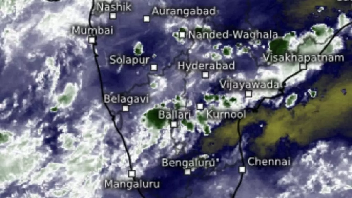
This track took it towards north interior Karnataka evening as rains spread out to parts of Telangana. Satellite pictures showed blobs of rain-bearing clouds hanging over an area bounded by Harpanahalli, Ilkal and Ballari in north interior Karnataka. Forecasts indicate the weakened ‘low’ will track towards coastal Karnataka/Goa before it drifts out into the adjoining Arabian Sea.
Extremely heavy rain lifts
In this manner, the heavy to very heavy rain that lashed north Tamil Nadu and south coastal Andhra Pradesh has been lifted. But the IMD has forecast isolated heavy rain for Tamil Nadu, Puducherry & Karaikal on Friday, Sunday and Monday; over South Interior Karnataka until Tuesday; and Kerala & Mahe on Tuesday and Wednesday. It will be fairly widespread to widespread to moderate for Kerala & Mahe, Lakshadeep and Karnataka for a week and scattered to fairly widespread to moderate over Tamil Nadu, Puducherry & Karaikal, Coastal Andhra Pradesh & Yanam, Rayalaseema and Telangana.
Rains for west India
The west-north-west track of remnant ‘low’ will bring scattered to fairly widespread to moderate rain also over Konkan & Goa and Madhya Maharashtra during next five days and isolated to scattered to moderate during subsequent two days. It will be isolated to scattered to moderate over Marathwada and Gujarat for five days and isolated light to moderate during subsequent two days. Isolated heavy rain is likely over Saurashtra & Kutch on Sunday and Monday and over Gujarat Region (north Gujarat, Ahmedabad and south Gujarat) on Saturday and Sunday.
Fresh ‘low’ over Bay
Meanwhile, the IMD said a fresh upper air cyclonic circulation is likely to form over north Andaman Sea around Sunday. It may descend to lower levels and set up a low-pressure area over central Bay of Bengal by Tuesday next, chances of which were mentioned in advance in these columns. It is likely to move to the north-west and intensify further. A likely depression is in the making here, but away from Tamil Nadu coast. Numerical model predictions take the intensified system towards north Andhra Pradesh-Odisha coasts by October 25 (Friday next) and later to West Bengal and the north-east.