Fresh low-pressure area may disrupt monsoon withdrawal over north-west India
South-west monsoon has started withdrawing from extreme north-west India almost a week behind schedule, but the ensuing transition season to the north-east monsoon may open up window for stray, localised circulations to flare-up, one of which is expected to intensify as a low-pressure area over the Bay of Bengal and track west over Central India by Wednesday.
The transition period will see seasonal winds reverse and become north-easterly over the Bay and Peninsular India to set up the north-east monsoon (winter monsoon or monsoon in reverse) by mid-October. This phase is also known to sow the seeds of strengthened ‘lows’ or depressions or even powerful cyclones, as the country’s east coast knows all too well.
Low-pressure area soon
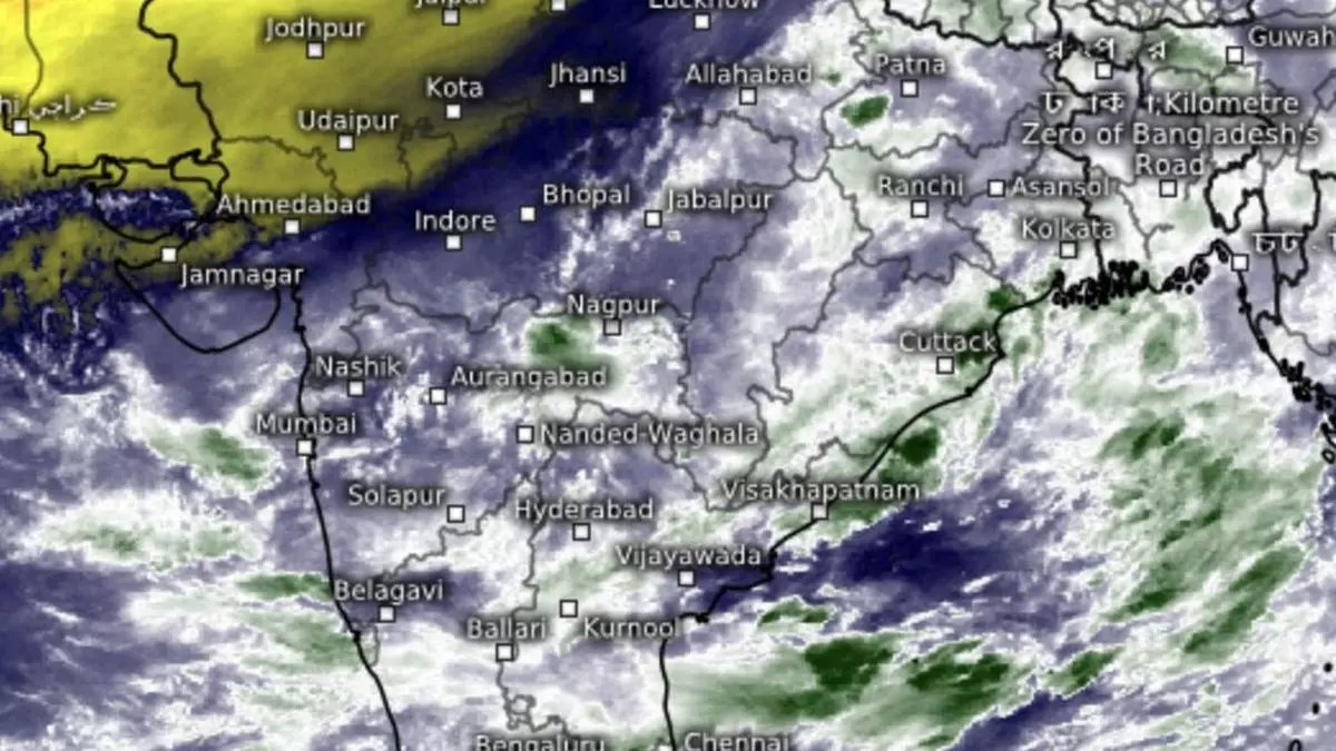
On Tuesday morning, India Meteorological Department (IMD) said an incoming cyclonic circulation (from South China Sea and drifting across Indochina) over Central Bay will descend to the lower levels to become a ‘low’ over west-central Bay soon. This is even as the line of withdrawal monsoon passes through Anupgarh, Bikaner, Jodhpur, Bhuj and Dwarka in Rajasthan and Gujarat.
Conditions are favourable for further withdrawal from more parts of West Rajasthan and adjoining Punjab, Haryana and Gujarat but may soon run into a hurdle that is likely being set up by the advancing ‘low’ as it negotiates the Andhra Pradesh coast and enters central India. The IMD track puts it on a course towards Telangana and further west-north-west into West Maharashtra and adjoining West Madhya Pradesh and Gujarat over the next few days, raining all across even as it weakens in the process.
Strengthening a bit?
The ‘low’ may undergo some strengthening over north-west Gujarat and adjoining south-west Rajasthan next week as the monsoon transition phase reaches its unpredictable best. A fresh cyclonic circulation may form over north Bay and navigate into east India as a rain-repellant anticyclonic circulation forms to farther south over south-east Bay, likely closing the door on further incursions by cyclonic circulations from the South China Sea/West Pacific.
Withdrawal on dock
But US Climate Prediction Centre says rain over central India may last until October 8 as the Bay sings in tune with drumbeats in the West Pacific/South China Sea. This phase may bring some rain briefly into the plains of north-west India. Monsoon withdrawal may briefly go into hibernation during this phase. In an outlook valid for the next seven days, the IMD saw the possibility of fairly widespread rain for Coastal Karnataka; for three days over Karnataka; Coastal Andhra Pradesh and Yanam; Rayalaseema and Telangana; and isolated to scattered light to moderate rain for entire week over Tamil Nadu, Puducherry and Karaikal.
Rain forecast
Over the South Peninsula, rain will be isolated extremely heavy over Coastal Karnataka and isolated heavy to very heavy over North Interior Karnataka; isolated heavy over Kerala and Mahe, Coastal Andhra Pradesh and Yanam, Rayalaseema, Telangana, and South and Interior Karnataka; on Wednesday over Coastal Karnataka, and Kerala and Mahe; on Tuesday and Wednesday over Telangana, and Coastal Andhra Pradesh and Yanam; and on Tuesday over Rayalaseema, North Interior Karnataka.
Outlook is for fairly widespread to widespread light/moderate rain over Konkan and Goa during the week, and over Madhya Maharashtra Marathwada for five days; isolated to scattered light to moderate for subsequent two days; scattered to fairly widespread for Gujarat Region (North Gujarat, Gandhinagar and South Gujarat); and isolated to scattered over Saurashtra and Kutch.
Extremely heavy
It would be isolated extremely heavy rain over Konkan and Goa on Tuesday and Wednesday, and isolated heavy to very heavy on Thursday; over Madhya Maharashtra until Thursday; over Marathwada on Tuesday; and over Gujarat on Wednesday and Thursday. It would be isolated heavy over Marathwada on Tuesday and Wednesday; over Gujarat Region for five days until Saturday; and over Saurashtra and Kutch from Thursday to Saturday.
Over Central India, it would be fairly widespread to widespread light over Vidarbha and Chhattisgarh for five days; isolated to scattered light over Madhya Pradesh on Tuesday and Wednesday; and scattered to fairly widespread light over the subsequent four days. It would be isolated heavy over Vidarbha and Chhattisgarh until Thursday; and over Madhya Pradesh until Friday.