Depression forms over Bay of Bengal, IMD upgrades outlook to deep depression by Monday
Saturday’s ‘well-marked’ low-pressure area concentrated into a depression over west-central and adjoining north-west Bay of Bengal early on Sunday morning centred over an area about 310 km east of Kalingapatnam (Andhra Pradesh); 260 km east-south-east of Gopalpur and 290 km south-south-east of Paradip (both in Odisha); and 410 km south of Digha (West Bengal).
India Meteorological Department (IMD) said the depression may move nearly northwestward towards north Odisha-West Bengal coasts and intensify into a deep depression by Monday. Thereafter, it likely to move west-north-westward across north-Odisha-Gangetic West Bengal; Jharkhand; and adjoining north Chhattisgarh during the subsequent two days.
Fuel from Yagi remnant
businessline had hinted in a report three days ago the likelihood of a deep depression, the third this season, over the Bay . Incoming remnant of typhoon Yagi from Vietnamis seen aiding intensification.
The seasonal land-based trough, know as the monsoon trough, remained south of its normal position where it is expected to continue for next 3-4 days. This southerly alignment caused the heavy rain belt swing back to west and central India at the expense of a rain-deficient north-west India. Large surplus Rajasthan so far this season signals skewed rain distribution over this region. A lone cyclonic circulation persisted over central Rajasthan & neighbourhood on Sunday morning as well.
Extremely heavy rain
The south-bound monsoon trough will trigger isolated extremely heavy rain is likely over Coastal Andhra Pradesh & Yanam on Sunday and Monday while it will be isolated very heavy over Coastal Andhra Pradesh & Yanam and Telangana. Isolated heavy rain is likely over Kerala & Mahe on both these days and over Coastal Andhra Pradesh & Yanam and Telangana on Tuesday; South Interior Karnataka until Tuesday; and Coastal Karnataka until Wednesday.
To spread out to east, too
The brewing deep depression will bring isolated extremely heavy rain to east over South Odisha on Monday, and isolated very heavy over Jharkhand on Tuesday and Wednesday; Odisha until Tuesday; over Assam & Meghalaya from Tuesday to Thursday; and over Nagaland, Manipur, Mizoram & Tripura on Tuesday and Wednesday. Isolated heavy rain may lash Assam & Meghalaya, Nagaland, Manipur, Mizoram & Tripura during next seven days; Odisha until Wednesday; Arunachal Pradesh from Tuesday to Friday; West Bengal & Sikkim and Jharkhand until Friday; and over Bihar, from Wednesday to Friday. Morning satellite pictures
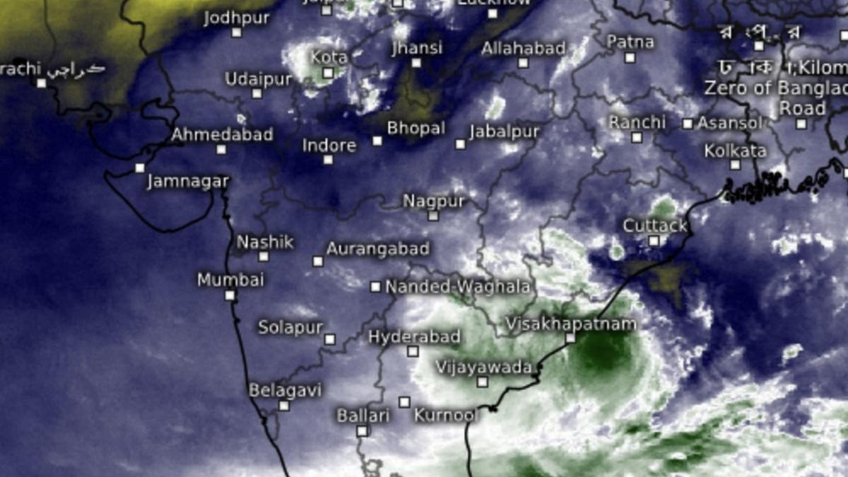
Morning satellite pictures
Morning satellite pictures on Sunday showed clouds/moderate rain spreading out over a swathe of Andhra Pradesh, Telangana and Odisha bounded by Ongole (Coastal Andhra Pradesh); Miryalaguda, Warangal and Ramagundam (Telangana); and Nabarangpur and Brahmapur (Odisha). Some of the areas falling under its footprint are Vijayawada, Rajahmundry, Amaravati, and Visakhapatnam (all Andhra Pradesh); Malkanagiri (Odisha) and Kothagudem (Telangana).
Rain for West India
An IMD outlook said fairly widespread to widespread light to moderate rain is very likely over West India during the week ahead while it would be scattered to fairly widespread light to moderate over Central India. Isolated very heavy rainfall is likely over ghat areas of Madhya Maharashtra on Sunday and Monday; and over Vidarbha on Thursday. It will be isolated heavy over Madhya Pradesh during next seven days; over Chhattisgarh and Konkan & Goa until Thursday; Vidarbha until Friday; Madhya Maharashtra until Tuesday; and over Marathwada on Thursday and Friday.
Widespread over South
Over the South, fairly widespread to widespread light to moderate rain is likely over Coastal Karnataka, Kerala & Mahe while it will be scattered to fairly widespread light to moderate over Coastal Andhra Pradesh & Yanam; Telangana; and Lakshadweep; isolated to scattered over Rayalaseema; Tamil Nadu; Puducherry & Karaikal; and Interior Karnataka during the week.