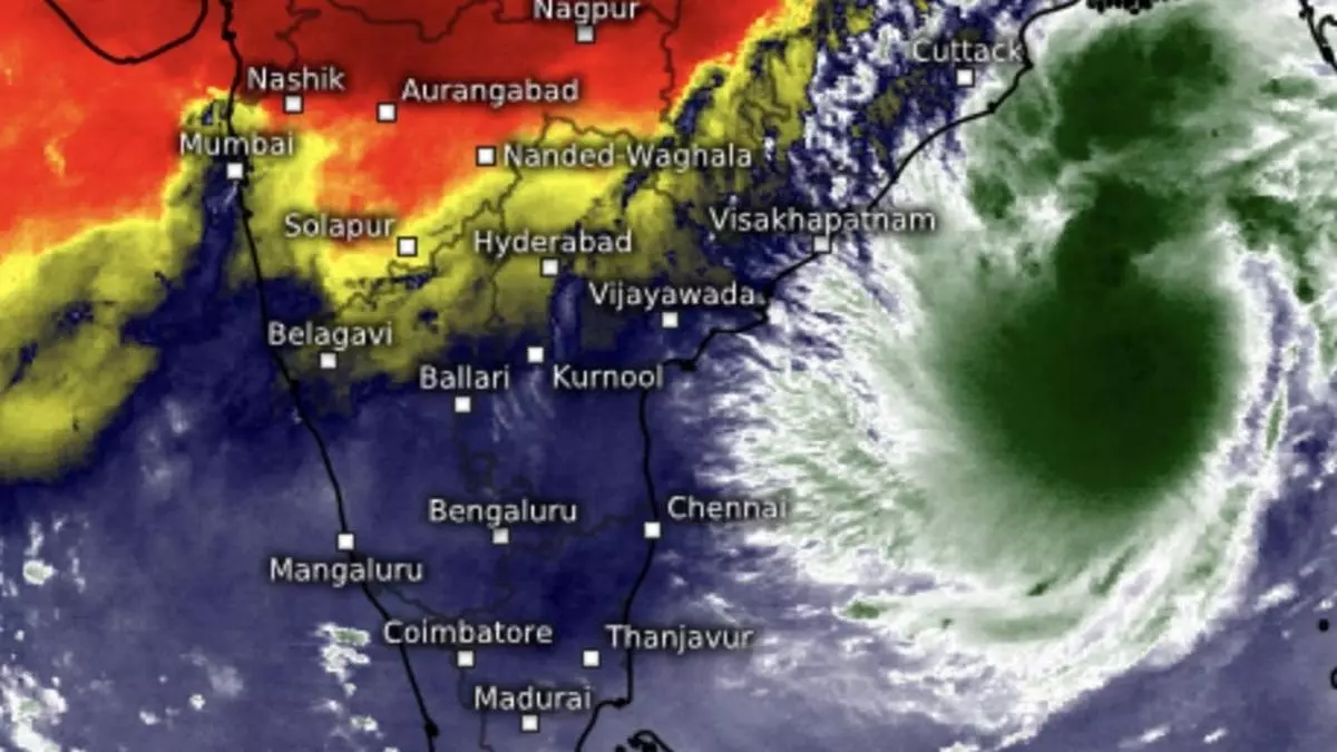
Cyclone Dana looms over east-central Bay, landfall by tomorrow over Odisha-West Bengal coast
Tuesday’s depression over east-central Bay of Bengal intensified twice over during the evening to night to become named cyclone Dana on Wednesday morning over the same region, and lay about 560 km south-east of Paradip (Odisha); 630 km south-southeast of Sagar Island (West Bengal); and 630 km south-southeast of Khepupara (Bangladesh).
Landfall as severe cyclone
Dana, a name contributed by Qatar, is very likely to move north-west and intensify into a severe cyclone over north-west Bay by early Thursday morning and cross north Odisha and West Bengal coasts between Puri and Sagar Island during the intervening night of Thursday and Friday morning as a severe cyclone with a wind speed of 100-110 km/hr gusting to 120 km/hr.
Dense cloud cover
Dense cloud cover associated with the cyclone and packing thunderstorms and high winds covered two-thirds of the Bay northward from west-central Bay on Wednesday morning. Outer cloud bands had reached the Sunderbans across the Indo-Bangladesh international border with the heaviest of rains to the south of Khulna in Bangladesh. International weather trackers are of the view the low vertical wind shear values (change in wind speed and direction with height) and elevated sea-surface temperatures will ensure steady development of the cyclone with no western disturbance predicted to cross its path.
Heavy rain forecast
India Meteorological Department (IMD) has forecast Light to moderate rain at most places with heavy rainfall at isolated places over Odisha on Wednesday and Saturday; and heavy to very heavy at a few places with extremely heavy rain at isolated places on Thursday and Friday. Light to moderate rain is also forecast at most places over the plains of West Bengal with heavy rain at isolated places on Wednesday and Saturday; and heavy to very heavy at a few places with extremely heavy rain at isolated places on Thursday and Friday. Light to moderate rain is likely at a few places over Jharkhand on Thursday at with heavy rain at isolated places; and heavy to very heavy rain at isolated places on Friday.
North-east India outlook
Over the north-east, light to moderate rain is likely at many places for next four days over Assam & Meghalaya and Nagaland, Manipur, Mizoram and Tripura accompanied with isolated thunderstorms and lightning. It will be light at isolated places during the subsequent three days. Light to moderate rain is likely at Isolated places over Arunachal Pradesh during next seven days and isolated heavy over on Wednesday; and over Assam & Meghalaya and Nagaland, Manipur, Mizoram & Tripura on both Wednesday and Thursday.
Rain for southern states
Towards the south, isolated heavy rain is likely over Tamil Nadu, Puducherry & Karaikal; and Karnataka, Kerala & Mahe on Wednesday; and over Coastal Andhra Pradesh & Yanam on Friday. Light to moderate rain is likely at many places accompanied with isolated thunderstorms and lightning over Tamil Nadu, Puducherry & Karaikal; Kerala & Mahe; and costal and south interior Karnataka during next three days while being light at isolated places over subsequent four days. It will be light to moderate at isolated places very likely over rest of the region during the week.