Cyclone Storm Dana: Threatens to pound Odisha and Bengal coasts with heavy rain
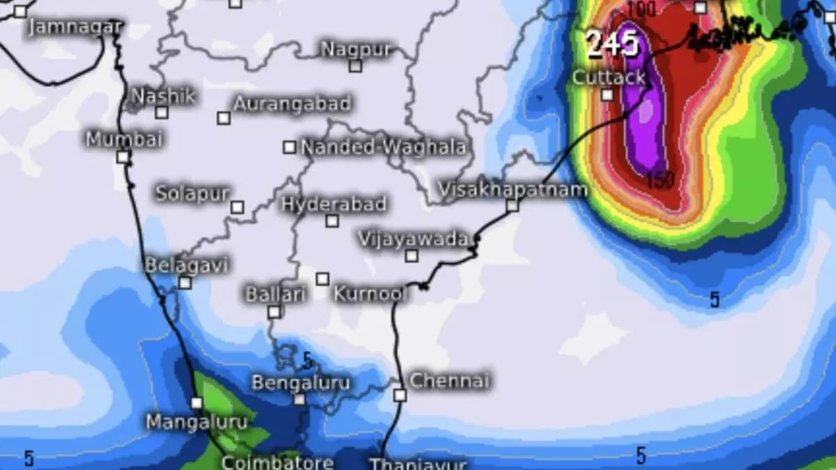
Cyclone Dana intensified into a severe cyclone by Thursday midnight, earlier than forecast, over central and adjoining north-west Bay of Bengal, and lay early on Thursday morning over north-west and adjoining central Bay, about 210 km south-east of Paradip (Odisha); 240 km south-southeast of Dhamara (Odisha); and 310 km south of Sagar Island (West Bengal).
India Meteorological Department (IMD) does not expect it to intensify further, and retained the outlook to maintain intensity as a severe cyclone while crossing north Odisha and West Bengal coasts between Puri and Sagar Island close to Bhitarkanika and Dhamara (Odisha) between midnight of Thursday and morning of Friday with wind speeds of 100-110 km/hr gusting 120 km/hr.
- Also read: IMD upgrades storm outlook to severe cyclone as ‘low’ becomes well-marked over Bay of Bengal
Gales winds are expected to gradually pick up in speed to 100-110 km/hr gusting to 120 km/hr along and off the north Odisha and the East Medinipur district of West Bengal from Thursday till Friday morning, as Dana homes in for a landfall. Gale winds reaching speed of 60-80 km/hr gusting to 90 km/hr are likely along and off south Odisha coast and remaining districts of coastal West Bengal from Thursday evening till Friday morning.
Sea condition worsen
The IMD has warned that sea condition along and off the Odisha-West Bengal coasts will be ‘high’ to very high’ (wave heights of 20-46 ft) till the forenoon of Friday by when the severe cyclone would make landfall. Over the north-west Bay also, from where the severe cyclone will make the final lunge for landfall, it may range from ‘high’ to ‘very high’ till Friday morning. Adjoining north-east Bay is likely to witness ‘rough’ to ‘very rough’ conditions (8-20 ft) during this period.
Storm surge threat
Storm surge of 1.0 to 2.0 metre in height above astronomical tide may inundate low-lying areas of Kendrapara, Bhadrak and Balasore districts of Odisha and East Medinipur in West Bengal during landfall. Storm surge of 0.5 to 1.0 m height above astronomical tide may inundate low-lying areas of South 24-Parganas district of West Bengal and Jagatsinghpur in Odisha.
Warning to fishermen
The IMD advised total suspension of fishing operations on Thursday and Friday over central and North Bay. They are are advised not to venture into the east-central Bay and adjoining west-central Bay as well. They should avoid venturing out into the north-west and adjoining north-east Bay and along and off the Odisha, West Bengal and Bangladesh coasts till Friday.
Heavy rain in South India
During the 24 hours ending on Thursday morning, rain was maximum however over the South Peninsula with Kerala and Tamil Nadu getting lashed by westerly flows over the south-east Arabian Sea from a cyclonic circulation over the Comorin region coupled with those those directed into the severe cyclone in the Bay.
Across the inter-state border, Idamalayar Dam, Thuckakay and Kelavarappalli Dam received 12 cm of rain each during this period, followed by (above 5 cm) Kovilpatti-11; Krishnagiri, Sankarapuram and Ambur-10 each; Nooranad, Bhavanisagar and Mavelikkara-9 each; Kalamassery-8; Kottarakkara, Thenmala, Kayamkulam, Pampadumpara, Valparai PTO, Vaniyambadi, Barur, PWD Makkinampatti, Mambzhathuraiyaru, Hogenekal, Anaikedanku and Thirparappu-7 each. Over East India, which faced the wrath of the incoming severe cyclone, Rupouli recorded 10 cm and Katihar 9 cm (both in Bihar). In neighbouring Jharkhand, Maheshpur recorded 9 cm of rain during the 24 hours ending on Thursday morning.
Hot spots of multi hazards
Vishwas Chitale, Senior Programme Lead, Council on Energy, Environment and Water (CEEW), a Delhi-based think-tank, saidcoastal states of Odisha and West Bengal are hotspots of multiple hazards such as floods, cyclones and droughts and face compounding impacts. These states have also experienced multi-fold increase in the number of cyclones in the past few decades. As per CEEW analysis, 18 districts in Odisha and nine in West Bengal are highly exposed to cyclones.
Multi-hazard early warning systems (EWS) play a crucial role in informing decision-makers and communities ahead of time to evacuate and reduce the potential losses, Chitale said. CEEW research highlights effectiveness of cyclone EWSs in India and finds cyclone multi-hazard EWS systems provide 100 per cent coverage to exposed population, with Odisha and West Bengal at the forefront of building resilience by establishing cyclone EWS. Flood early warning systems can be further strengthened to achieve 100 per cent coverage of the flood-prone population through investments in innovation and technology.
